The Jet Stream and Us: A high-altitude aerial superhighway, a ribbon of wind surging at speeds exceeding 200 miles per hour – this is the jet stream, an atmospheric phenomenon that has shaped human history and continues to mold our future. This captivating documentary traces our evolving understanding of the jet stream, from its mystifying effects on World War II bomber pilots to its pivotal role in modern aviation, extreme weather events, and the changing climate.
The jet stream is a weather maker, a force of both creation and destruction. It has been a silent partner in some of the most significant events of the past century. During World War II, it bewildered bomber pilots, altering their flight paths and bomb trajectories. In modern times, it has become an ally to transatlantic flights, propelling aircraft across the ocean with remarkable speed and efficiency. Yet, it has also unleashed its fury through devastating storms like the infamous 1987 hurricane and catastrophic floods, leaving trails of destruction in its wake.
Scientists, including the esteemed Sir Brian Hoskins of the University of Reading and Kirsty McCabe from the BBC Weather Centre, share their insights and expertise in this compelling documentary. They reveal how the jet stream, a dynamic and ever-changing entity, is intimately linked to our weather patterns and climate. Its fluctuations and shifts have far-reaching consequences, influencing temperatures, precipitation, and the frequency and intensity of extreme weather events.
The documentary delves into the intricate relationship between the jet stream and climate change. As our planet warms, the jet stream is responding in complex and unpredictable ways. There is growing evidence that it is changing its behavior, becoming more erratic and prone to extreme swings. These changes have the potential to disrupt weather patterns, leading to prolonged heatwaves, droughts, floods, and other climate-related disasters.
The implications of a changing jet stream are profound, affecting agriculture, water resources, infrastructure, and the delicate balance of ecosystems. The documentary explores how these changes will impact our daily lives, from the food we eat to the energy we consume and the way we plan for the future.
“The Jet Stream and Us” is a timely and thought-provoking documentary that sheds light on a critical force of nature that is undergoing significant transformations. It is a story of discovery, adaptation, and resilience as we grapple with the challenges of a changing climate. By understanding the jet stream and its evolving role in our world, we can better prepare for the future and make informed decisions to protect our planet and ourselves.
The Jet Stream: A Powerful Force Shaping Weather Patterns
High above the Earth’s surface, in the upper levels of the atmosphere, exists a phenomenon of immense power and influence known as the jet stream. These swift, narrow currents of air, typically flowing from west to east, play a pivotal role in shaping weather patterns across the globe. Understanding the jet stream is key to comprehending the complex dynamics of our atmosphere and the ever-changing weather we experience.
At its core, the jet stream is a ribbon of fast-moving air, often exceeding speeds of 100 miles per hour. These air currents are not uniform in strength or location. Instead, they meander and shift, forming wave-like patterns that extend for thousands of miles. The jet stream’s position and intensity vary throughout the year and are influenced by a multitude of factors, including the Earth’s rotation, temperature differences between the equator and the poles, and the distribution of land and water masses.
There are two primary types of jet streams: the polar jet stream and the subtropical jet stream. The polar jet stream, located closer to the poles, is typically stronger and more variable than its subtropical counterpart. It is this powerful air current that most significantly influences weather patterns in the mid-latitudes, where much of the world’s population resides. The subtropical jet stream, located closer to the equator, is generally weaker and less prone to dramatic fluctuations.
The jet stream’s influence on weather is far-reaching. It acts as a steering current for weather systems, guiding their movement and determining their intensity. For example, the jet stream can propel storms across continents, bringing rain, snow, and wind to vast regions. Conversely, it can also create areas of high pressure, leading to clear skies and calm conditions. The jet stream’s position and strength can also influence temperature patterns, causing warm or cold air masses to move into certain regions.
In recent years, scientists have observed changes in the jet stream’s behavior that may be linked to climate change. Some studies suggest that the jet stream is becoming more erratic and prone to extreme fluctuations, leading to more frequent and intense weather events such as heatwaves, droughts, floods, and storms. While the exact relationship between the jet stream and climate change is still under investigation, it is clear that this powerful air current is a critical component of the Earth’s climate system and a key factor in determining our weather.
Beyond its influence on weather, the jet stream also plays a role in aviation. Pilots often utilize the jet stream to their advantage, riding its tailwinds to reduce flight times and fuel consumption. However, the jet stream can also pose challenges for aviation, as its turbulent nature can create bumpy rides for passengers and require aircraft to alter their flight paths.
In conclusion, the jet stream is a fascinating and complex phenomenon that exerts a profound influence on our planet’s weather patterns. Its meandering path and fluctuating intensity create a dynamic atmosphere, where weather systems are constantly evolving and shifting. Understanding the jet stream is crucial for meteorologists, pilots, and anyone interested in the intricate workings of our planet’s climate system. As we continue to explore the jet stream’s mysteries, we gain valuable insights into the forces that shape our weather and climate, ultimately enhancing our ability to predict and prepare for the challenges and opportunities that lie ahead.
The Jet Stream and Us
The story of The Jet Stream and Us is one of dramatic contrasts. The glorious British summer of 2006 saw soaring high temperatures with day after day of blue skies. Just one year later, a completely different story unfolded. The summer of 2007 was one of the wettest since records began. These weather extremes raise critical questions. Are they mere aberrations, or are they part of an emerging pattern? A powerful force, located six miles above us, holds the answer.
This atmospheric river drives some of the most destructive weather on the planet, including powerful storms and even tornadoes. Now, scientists believe this force is shifting, fundamentally changing our weather and posing a challenge that affects everyone. Understanding this phenomenon is crucial, as its behavior will determine our future climate. The key question we face is what our climate will become and what adaptations we must make to survive.
This article traces our evolving understanding of this atmospheric driver, exploring the journey of The Jet Stream and Us. We will examine its accidental discovery during wartime and follow how scientific knowledge grew over the decades. The narrative will cover its awesome power to shape our world, from creating devastating storms to enabling record-breaking flights. Finally, it will address the most pressing issue of our time: how this force is changing and what it means for our future.
The force in question is known as the jet stream. It is a river of high-speed wind that constantly circles the Earth. This powerful current is a fundamental driver of global weather patterns. Its position and strength directly influence whether we experience sunshine or storms. For those in the United Kingdom, our national obsession with the weather should perhaps be an obsession with the jet stream, as it so uniquely dictates our daily conditions.
Scientists now have evidence that this critical feature of our atmosphere is changing its behavior. The long-term position of the jet stream appears to be shifting. If this trend continues, it will cause a dramatic and permanent alteration in our regular weather patterns. This presents one of the most important problems for humankind. Answering questions about the jet stream’s future is paramount to understanding the climate we will have to adapt to.
Our knowledge of this phenomenon did not begin with meteorologists poring over charts. Instead, it was first encountered by World War II bomber pilots just over 60 years ago. These pilots flew the legendary B-29, the first heavy bomber designed to cruise at the very high altitude of 30,000 feet. This height advantage was meant to keep them above enemy flak and fighters. It was at this altitude, six miles high, that they stumbled upon one of the most important forces on our planet.
An Unseen Enemy in the Skies
In November 1944, the 73rd Bomb Wing embarked on its first strike against Tokyo. The mission plan relied on the B-29’s ability to perform accurate, precision bombing from its high cruising altitude. The planes were equipped with the top-secret Norden bombsite. This advanced instrument compensated for the plane’s speed over the ground to ensure accuracy. It was this very instrument that would provide the first indication of something mysterious and unknown in the upper atmosphere.
As the bombers climbed to their operational altitude of 37,000 feet, the crews prepared for their bombing run. When they turned towards their target in Tokyo, they realized they had a major problem. The Norden bombsite simply would not lock onto the target. The aiming telescope kept moving out in front of the target, indicating the plane was overshooting it. A check with the radar operator revealed a shocking fact: the plane’s ground speed was approximately 480 miles per hour, far faster than the 340 mph it should have been traveling.
The crew discovered they were flying in a 125-knot tailwind. They had experienced, for the first time, a wind at 30,000 feet as fast and powerful as a hurricane. The advanced bombsite could not cope with such a high ground speed. As they hurtled past their targets, they had no option but to abandon the mission and drop their bombs, which landed 12 miles past the intended area. This powerful, high-altitude wind was completely unheard of at the time.
When the crews returned, their story was met with disbelief. Interrogators gave them the third degree, insisting that a 140-mile-per-hour wind over Japan was impossible. They accused the men of lying to cover up a failed mission. Fortunately, a high-ranking operations officer had flown with them as a passenger. He vouched for their story, confirming that he had heard the radar operator report the incredible wind speed. His testimony was crucial in convincing the command that the crews had encountered a real and extraordinary phenomenon.
Piecing Together a Global Puzzle
While American pilots were grappling with this invisible force, evidence of its existence was mounting elsewhere. During the same campaign, meteorologists forecasting the high-altitude weather over Tokyo made predictions that seemed impossible. Using limited data from submarines, they calculated that the winds at 30,000 feet would be 168 knots. When they presented this forecast, a general chewed them out for such a “stupid” prediction. The general then flew a mission to measure the winds himself.
Upon his return, it was clear the forecast had been correct. One crew after another told the same story of encountering phenomenal winds. To his credit, General O’Donnell returned the next day and apologized to the meteorologists. The existence of the wind was no longer in doubt. In one instance, a reconnaissance plane flying from east to west against the wind found it was moving three miles per hour backwards, making it a sitting duck for Japanese fighters. It was clear this was not a freak event, but a persistent “river of air.”
Unbeknownst to the Allies, the Japanese military already had some knowledge of this phenomenon. They had come across research done 20 years earlier by a little-known meteorologist, Wasaburo Oishi. Oishi was one of the great observationalists of the 20th century. Using basic equipment called pilot balloons, he had measured the high-altitude winds over Japan. By tracking these hydrogen-filled balloons with a telescope, he could determine horizontal wind speeds.
Oishi published his findings on high winds in the upper atmosphere in 1926. Unfortunately, his achievement was not recognized by the international scientific community. He published his report in Esperanto, the international language, believing it would be well-received. Instead, almost no one in the rest of the world read it. Nearly 20 years later, however, the Japanese military exploited his research with tragic consequences.
Based on Oishi’s work, the military theorized that balloons launched near Tokyo could be carried across the Pacific. They launched thousands of bomb-carrying balloons, hoping they would reach the western United States. It was a guess, as they did not know if the winds extended that far. But in 1944, the balloons began to appear. In May 1945, a group on a Sunday school picnic in Bly, Oregon, discovered one. The resulting explosion killed five children and one adult, the only civilians killed by enemy action on the American mainland during the war.
Defining the River of Air
The Japanese balloon bomb campaign marked a turning point. It proved that the high-altitude winds were not a local phenomenon over Japan. Instead, they stretched at least a quarter of the way around the world. After the war, meteorologists intensified their investigations. They began to track these winds across the planet and understand their significance for global weather events. This river of high altitude air became known as the jet stream.
Scientists learned that the jet stream is a flow of wind from west to east. It becomes very concentrated in certain regions, transporting a huge amount of air as it meanders around the hemisphere. There are two major jet streams, one in each hemisphere. The one that primarily affects weather in Europe and North America is in the northern hemisphere. It forms at high altitude where warm air from the tropics meets cold air from the North Pole.
This temperature contrast generates a high-speed wind. As the Earth rotates, this fast-moving air streams around the planet. The greater the temperature difference, the faster the jet moves. The jet stream can be as straight as a die, but it often snakes from side to side. It is a remarkably tight ribbon of air, only about 100 to 200 kilometers wide in latitude and just one or two kilometers in its vertical extent. Its speeds can range from 70 to over 200 miles an hour.
The United Kingdom sits in a unique position relative to this atmospheric current. The westerly jet stream starts over North Africa, continues over Asia and the Pacific, and then crosses North America. After this long journey, it arrives just over the UK, forming a huge spiral. As one expert noted, “We’re at the end of that spiral. We’re at the graveyard of the jet stream and of the storms on that jet stream.” This location makes its behavior uniquely significant for British weather.
Riding and Fearing the Atmospheric Current
The raw power of the jet stream can be experienced directly in some of the world’s most extreme environments. The Himalayas, with peaks like Mount Everest reaching 29,000 feet, are high enough to be swept by the jet. The familiar image of a plume of snow blowing off Everest’s summit is a direct result of the jet stream’s force. This provided an opportunity for mountaineer and cameraman Leo Dickinson to experience it firsthand.
In 1991, Dickinson attempted to fly over the summit of Mount Everest in a hot air balloon, hitching a ride on the jet stream. After taking off, his balloon climbed to 26,000 feet. At that altitude, it entered the jet stream. He described the feeling as if a hand had grabbed the top of the balloon, which was 150 feet higher than the basket. The top of the balloon was pulled along first, causing the basket to swing like a pendulum until the entire craft was inside the current, at which point it settled down.
Now traveling at 65 knots straight for Everest, the team faced a critical challenge. Meteorologists had warned them to stay at least 3,000 feet above the summit. When the jet stream hits Everest, the air that goes over the top curls into a great “rotor.” Getting caught in this rotor would force the balloon down uncontrollably. As they approached, they fired their burners at full blast, successfully rising above the danger zone and becoming the first men to ride the jet stream over Everest.
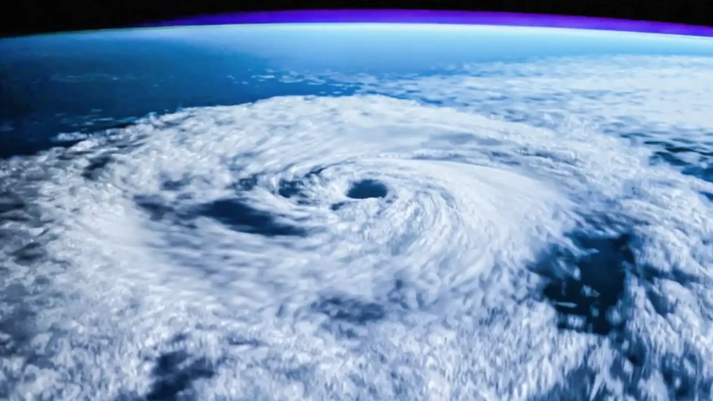
The same atmospheric force is involved in creating one of nature’s most destructive phenomena: tornadoes. In the central plains of the United States, known as Tornado Alley, conditions are often perfect for their formation. Warm, moist air from the Caribbean rises over colder air, forming clouds that climb thousands of feet. High up, the fast-flowing jet whips away air from the top of the storm cloud. This action can cause the entire storm to rotate, becoming a “supercell,” beneath which the deadly vortex of a tornado can develop.
The jet stream’s influence is not limited to the northern hemisphere. In 1947, a scheduled flight named Stardust was crossing the Andes en route to Santiago, Chile. The plane, with its crew and six passengers, vanished without a trace. The mystery endured for over 50 years until its wreckage was discovered at the foot of a glacier in 2000. Researchers pieced together what happened. The pilot had climbed to 24,000 feet to fly over a storm, placing the plane directly in the path of the southern jet stream.
At the time, very little was known about the jet stream. The pilot was unaware that a powerful headwind was dramatically slowing his plane down. With no radar and heavy cloud cover below, the crew believed they had cleared the mountains. When they began their descent for Santiago, they were in fact flying straight into the face of the Andes. The plane crashed into a glacier, and the impact triggered an avalanche that buried the wreckage for decades.
Today’s airline pilots are well aware of the jet stream’s precise location. This knowledge is not just for safety, but also for saving money. Flight paths are calculated to either use or avoid the jet stream. When flying from Europe to America, pilots often take a longer route to avoid the horrendous headwind. On the way back, however, if a pilot can get the plane into the jet stream, the journey can be substantially quicker, saving millions of pounds in fuel costs annually.
While a powerful jet stream can be an ally to airlines, it can also be a harbinger of severe weather. The jet stream doesn’t just steer storms; it provides the basic energy for them to form. In December 1999, passengers on flights from New York to Paris enjoyed an unusually swift journey, propelled by a 200-mile-an-hour jet stream. What they did not realize was that the very force pushing them across the Atlantic was also whipping up a devastating storm that tore through Paris with hurricane-force winds.
In the United Kingdom, the Met Office has the crucial job of tracking the jet stream and the weather fronts it carries. Meteorologists see it as the engine of the atmosphere, forcing the development and movement of depressions. A satellite image clearly shows the line of the jet stream, and a forecaster’s job is to predict whether it will steer bad weather towards or away from the UK. This complex information is then relayed to forecasters at places like the BBC Weather Centre.
Meteorologist Kirsty McCabe explains that understanding what the jet stream is doing helps her craft her weather story for viewers. However, despite its importance, the jet stream is rarely mentioned in UK weather forecasts. This is in contrast to America, where its position is often included. The reason may be a reluctance to credit the British viewer with enough understanding of the complex weather science involved.
The impact of the jet stream’s position was starkly illustrated in the summer of 2007. Typically, the summer jet stream flows to the north of the UK, steering low-pressure systems towards Iceland and Scandinavia. In 2007, however, the jet stream moved much further south. This meant all the low pressures that formed in the Atlantic were steered directly towards the UK, which was hit by storm after storm, leading to a horrendous amount of rain and devastating floods.
The jet stream’s speed is just as important as its position. The great storm of October 1987 was a superb example of its power. A fantastic, very strong, and straight jet stream formed over the Atlantic. As one expert described it, “It was like a gun pointing to us. We were at the end of the barrel of that gun.” The storm developed with incredible speed, forming in just six hours and catching meteorologists largely by surprise. This led to the infamous forecast by Michael Fish, who reassured a viewer that there was no hurricane on the way. The country went to bed unprepared for the chaos that followed.
A Shifting Pattern and an Uncertain Future
The technology available in 1987 was relatively primitive. Computer models could only forecast a single outcome, and on that day, the prediction was wrong. Today, more powerful computers model a range of possibilities. When these modern models are applied to the 1987 data, they show that tiny, almost imperceptible differences in the initial conditions led to two vastly different outcomes: one with a minor weather system and one with an intense vortex and destructive winds. Michael Fish was simply given the wrong forecast to disseminate.
While tracking the jet stream day by day is now routine, establishing its long-term pattern is far more difficult but critically important. The long-term position of the jet stream appears to be changing. Evidence for this began to emerge in the 1990s in America. The state of Idaho experienced an unusual number of forest fires over five years, caused by long-term drought conditions. The culprit was suspected to be the jet stream, which had shifted its position to the north, allowing persistent high pressure to dominate and dry out the region.
This change is not just happening over America. Evidence from Europe also suggests the jet stream is moving from its regular path. Scientists believe they are seeing a general poleward movement of the jet. This shift is thought to be associated with global warming. As more carbon dioxide is added to the atmosphere, warming increases, and the jets continue to move northward. While the theory is strong, the confidence level is not yet as high as it is for the direct link between carbon dioxide and warming.
If this northward shift continues, it will have a profound impact on UK weather. We can generally expect warmer, wetter winters, which may lead to more frequent flooding. In the summer, we can expect higher temperatures and more intense rainfall events, causing localized summer flooding. Flood risk is one of the most obvious ways climate change will impact how people live in the UK. With 1.8 million homes located in designated floodplains, the consequences could be catastrophic.
The Complexities of Climate and The Jet Stream and Us
The floods of 2007 cost insurance companies an estimated three billion pounds. Dr. Robert Muirwood, who advises insurers on climate change risks, notes that companies are starting to question if widespread coverage can continue. Premiums may rise to discourage building in floodplains, and people may have to take more responsibility for making their homes flood-proof. How we manage flood risk is set to become a very significant political issue.
However, a simple northward shift is not the end of the story. Scientists believe the jet stream’s behavior might be changing in another way, related to something called a “blocking event.” The harsh winter of 1963, when Britain was in the grip of a great freeze for three months, was caused by such an event. A block is essentially a blockage of the jet stream, preventing the usual westerly winds and storms from reaching Great Britain. Instead, the storms are diverted far to the north or south.
During winters like 1963, areas of cold air from the east would park over the British Isles, splitting the jet stream and stopping its warmer, wetter weather. Since the 1960s, these blocking events have become less frequent. This is why we now tend to have winters characterized by the jet stream bringing warmer and wetter weather into Western Europe.
This trend seems to reinforce the soggy future predicted by the northward shift. Yet, there is a twist. Blocking events are extremely difficult to predict, even with sophisticated climate models. Some scenarios of climate change suggest we might get more of them, not fewer. This would lead to a very different kind of weather for Britain. If the world gets warmer but we experience more winter blocking events, our winters could actually get colder.
If these blocking events were to happen more frequently in the summer, our summers would become much, much hotter. In this scenario, we would not be worried about summer flooding, but about intense heat and drought. The challenges this would bring are immense. A 2001 incident where thousands of passengers were trapped on the London Underground in 40-degree heat is a cautionary tale for what could become a more common reality. A Britain with boiling hot summers would require significant and costly re-engineering to cope.
Charting Our Course on a Shifting River of Air
So, where does this journey leave us? We’ve traveled from the skies over war-torn Japan, where bewildered pilots first battled an invisible atmospheric foe, to the sophisticated computer models of today that attempt to predict our planet’s future. For decades, the story of the jet stream was one of discovery—a gradual peeling back of layers to reveal the engine driving our global weather. We learned its secrets, mapped its currents, and even learned to hitch a ride on its powerful back. Yet, just as we reached a level of understanding, the jet stream began to change its tune, presenting us with a profound and unsettling uncertainty.
The central takeaway is not simply that our climate is changing, but that the mechanisms driving that change are themselves complex and unpredictable. The jet stream is no longer a reliable, albeit powerful, feature of our atmosphere; it has become a variable in an equation we are desperately trying to solve. We are faced with two starkly different potential futures, both born from the same phenomenon.
One path leads to warmer, wetter winters and increasingly severe floods—a future where raincoats and flood barriers become our most essential tools. The other, driven by an increase in blocking events, could paradoxically plunge us into colder winters while simultaneously baking us in intensely hot, dry summers, threatening our infrastructure with heat and our landscapes with drought.
Think of it as navigating a great river that has begun to carve a new path. For years, we learned to read its currents and anticipate its floods. Now, we find ourselves at a fork, unsure which direction the main channel will flow. Will it overflow its banks consistently, or will it divert its course, leaving parts of its old bed dry while flooding others unexpectedly? This is the critical question facing climate science today. The answer determines not just whether we invest in better drainage or more robust air conditioning, but how we fundamentally design our societies for the coming decades.
Our relationship with this atmospheric river has come full circle. Once an unknown force that could throw bombers off course, it is now a known agent of change whose future trajectory remains tantalizingly out of focus. The challenge is no longer just to understand the jet stream as it is, but to anticipate what it will become.
The work of scientists to refine their models with ever-more-powerful supercomputers is not an abstract academic exercise; it is the most critical reconnaissance mission of our time. Getting it right will allow us to adapt and build a resilient future. Getting it wrong could leave us unprepared for the profound weather extremes that lie ahead. The story of the jet stream and us is far from over; in truth, the most critical chapter is just beginning.
F.A.Q. The Jet Stream and Us
Q: What is the jet stream and how does it impact weather patterns?
A: The jet stream is a high-altitude, fast-moving air current that circles the Earth. It acts as a steering mechanism for weather systems, influencing their movement, intensity, and overall patterns. Changes in the jet stream’s behavior can lead to significant shifts in weather conditions, including temperature fluctuations, precipitation patterns, and the occurrence of extreme weather events.
Q: How is the jet stream connected to aviation?
A: The jet stream plays a crucial role in aviation, particularly for long-haul flights. Pilots strategically utilize the jet stream’s tailwinds to reduce flight times and fuel consumption, leading to more efficient and cost-effective air travel. However, the jet stream’s turbulence can also pose challenges, requiring pilots to adjust flight paths for passenger comfort and safety.
Q: Are there different types of jet streams?
A: Yes, there are two primary types of jet streams: the polar jet stream and the subtropical jet stream. The polar jet stream, located closer to the poles, is generally stronger and more variable, significantly impacting weather in the mid-latitudes. The subtropical jet stream, closer to the equator, is typically weaker and less prone to dramatic fluctuations.
Q: How is climate change affecting the jet stream?
A: Recent research suggests that climate change is influencing the jet stream’s behavior. Some studies indicate that the jet stream is becoming more erratic, leading to increased frequency and intensity of extreme weather events such as heatwaves, droughts, floods, and storms. While the exact relationship is still under investigation, understanding this connection is vital for predicting and mitigating future climate impacts.
Q: What are the implications of a changing jet stream for our planet and society?
A: The jet stream’s evolving behavior carries significant implications for both the environment and human society. Changes in the jet stream can disrupt weather patterns, affecting agriculture, water resources, infrastructure, and ecosystems. Understanding and adapting to these changes are crucial for ensuring food security, water management, disaster preparedness, and the overall well-being of our planet and its inhabitants.