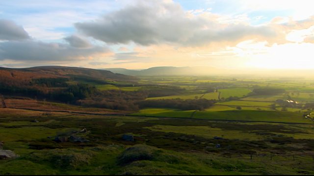
Countryfile — The River Leven through Time takes Anita Rani and Joe Crowley along one of Fife’s most historically significant waterways, tracing how the River Leven shaped the communities that grew beside it and how those same communities are now reshaping their relationship with it. This is a river with centuries of industrial muscle behind it, and this episode sets out to understand what that legacy left behind — and what it might still offer.
Anita Rani joins archaeologists on a major new excavation along the riverbank, unearthing the physical evidence of the Leven’s working past. The dig targets layers of history that the river itself has kept hidden, giving researchers their first close look at how industry and daily life intertwined here across generations. Rani’s presence grounds the archaeology in something accessible — this is not a detached academic exercise but a genuine attempt to reconnect people with ground they walk past every day without understanding.
From the excavation, the episode widens its focus to the human side of that reconnection. Local communities along the River Leven have been separated from the water for longer than most residents can remember, and the people working to change that are central to this part of the programme. Their efforts reflect a broader pattern playing out across post-industrial Britain: rivers that once drove factories and mills now offer something quieter but no less valuable, and the work of bringing communities back to the waterside matters precisely because it does not happen by itself.
Joe Crowley heads to Loch Leven, where the river begins, and gets hands-on with one of the last working sluices still operating on the water. The sluice is a direct physical link to the era when controlling the river’s flow was an industrial necessity, and Crowley’s engagement with it makes that engineering logic immediate and legible. Understanding how a sluice works is understanding how an entire economy of water-powered industry functioned — and why managing the river’s output still carries practical importance today.
Loch Leven also places Crowley at the centre of one of the UK’s longest-running lake research programmes. Scientists here have been monitoring the loch’s health for decades, tracking changes in water quality, ecology, and the wider environmental signals that a body of water this significant can provide. The lake is the river’s source, and what happens at Loch Leven determines what flows downstream. That makes the research not just scientifically valuable but directly relevant to everything else happening along the River Leven corridor.
The research programme gives this episode one of its sharpest points of focus. Scientists study long-running lake health to detect environmental change with precision that shorter datasets cannot provide. Decades of monitoring at Loch Leven have produced a record detailed enough to identify trends, anomalies, and the slow shifts that only become visible over time. That accumulated knowledge informs how the river is managed and how future interventions might be planned.
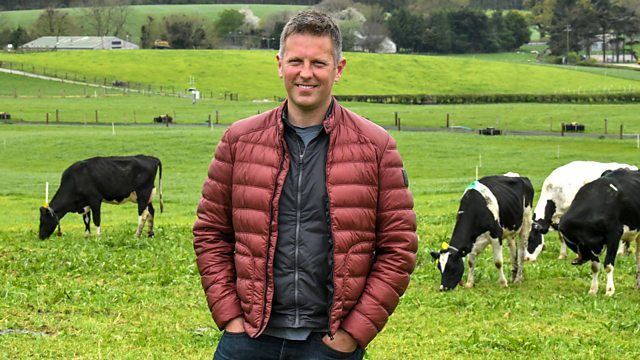
Meanwhile, Adam Henson returns to his Cotswolds farm for the annual spring plant surveys. The surveys track how the landscape is shifting year by year, measuring change at the slow, ground-level pace that makes the data genuinely useful. Henson’s farm provides a counterpoint to the Fife sequences — not a river but a field, not an industrial past but an agricultural one, and not excavation but observation. The connection is the same underlying question: what does the land remember, and what is it telling us now?
The plant surveys matter because landscape change is rarely dramatic. A species arriving or retreating, a flowering pattern shifting by a week or two — these are the signals that careful annual recording catches. Henson’s farm has become a long-term reference point, and the spring surveys make that ongoing record concrete and visible for an audience that might otherwise find ecological monitoring abstract.
Countryfile – The River Leven through Time
Countryfile — The River Leven through Time works because it treats industrial heritage not as nostalgia but as active context. The Leven is not being remembered as a relic; it is being read as a document. The archaeologists digging into its banks, the scientists monitoring its source at Loch Leven, and the community workers restoring access to its banks are all engaged in the same project: understanding what this river has been in order to make better decisions about what it becomes. Anita Rani and Joe Crowley move through that process with the curiosity and directness that make the best Countryfile episodes feel less like television and more like a genuine conversation about place.
The episode closes no tidy loop. The excavation will continue, the research programme will keep running, and the communities along the River Leven will keep finding their way back to the water at their own pace. That openness is the point. Rivers do not resolve — they move, they change, and they carry the marks of everything that has happened along their banks. This episode follows that logic and is stronger for it.
Countryfile – The River Leven through Time
The major environmental feature Countryfile – The River Leven through Time highlights how Scotland’s industrial waterways are transitioning from forgotten channels of manufacturing into vital hubs of community regeneration and ecological preservation. Flowing through the heart of Fife, the River Leven runs for 29 miles from its source at Loch Leven down to the Firth of Forth at Levenmouth.
For centuries, this hard-working waterway shaped local communities, powering more than 30 mills downstream and acting as a great powerhouse to industry. However, decades of intense industrialization, pollution, and subsequent neglect took a heavy toll on its waters and surrounding habitats. Today, a new chapter is unfolding as major restoration work attempts to breathe life back into the wildlife and the people who live alongside it.
Understanding the modern revival of this waterway requires examining its complex history, where human engineering radically altered the natural landscape. In the 1830s, engineers completed a massive infrastructure project to regulate the river’s flow, ensuring a consistent year-round supply of water for the region’s expanding lint, spinning, corn, linen, and paper mills. This intervention fundamentally reshaped the landscape, lowering the level of Loch Leven by 1.4 meters to expose valuable agricultural land on the east side of the loch that was previously entirely underwater. The legacy of this intensive manufacturing era left deep environmental scars, leaving the river cut off from local communities when industry declined in the latter half of the 20th century.
The current transformation of the River Leven represents a shift in how society views urban and rural water systems. Instead of treating rivers purely as industrial tools or disposal channels, modern conservation efforts focus on holistic landscape management, biodiversity tracking, and community ownership. This editorial feature explores the multi-layered initiatives revitalizing the Leven catchment, from archaeological excavations at Methil Mill and the continuous scientific monitoring of Loch Leven’s fragile ecosystem to nature-friendly farming experiments in the Cotswolds and ambitious urban parkland developments in Levenmouth.
Countryfile – The River Leven through Time Uncovers 16th-Century Industrial Roots at Methil Mill
On the banks of the River Leven at Methil Mill, archaeologists have launched a brand-new, three-year excavation project to uncover one of the earliest industrial sites along the river. This dig is breaking ground beneath the surface to provide the first tangible clues of how people began living and working beside a water source that once drove Scottish manufacturing. Lead site managers Dr. Paul Murtagh and Madison Reavis are overseeing the project to understand the precise historical operations of the mill and the profound role the river played in shaping early community life.
The excavation has already revealed that Methil Mill likely operated as an old corn mill dating back to the 16th century. Unlike many historic industrial sites across Scotland that have been lost to modern urban development in major towns and cities, this location remains uniquely preserved due to its distinct rural setting. This isolation allows archaeologists to unearth pristine layers of structural and social history from the 16th and 17th centuries, offering rare insights into early manufacturing practices and everyday human life along the water.
Working systematically from the topsoil downward, the archaeological team uncovered unexpected structural features, including a substantial chunk of modern concrete covering older hidden surfaces. As the dig progressed into deeper, older layers of earth, volunteers discovered a section of historical brick flooring, which site researchers suspect served as an ancient fireplace hearth. These physical structures help paint a vivid picture of the domestic and commercial environments that sustained the river’s earliest workers.
How Medieval Pottery and Modern Irn-Bru Bottles Chart Social Transformation Along the Leven
The artifacts pulled from the trenches at Methil Mill offer a fascinating chronology of human consumption across distinct eras. Among the most significant early discoveries is a piece of potentially medieval pottery. While typical medieval ceramics were notoriously chunky, this specific fragment is remarkably thin and features a distinctive dull green glaze sheen that is chipping away in places. This green-glazed style provides essential diagnostic evidence that helps researchers date the site’s earliest periods of intense human activity.
In sharp contrast to the centuries-old pottery, the trench walls also yielded much more recent social artifacts, illustrating the continuous human presence at the mill site up until the 1970s. Excavators unearthed a remarkably thick, solid Irn-Bru bottle estimated to be roughly 50 years old. The sheer thickness of the vintage glass highlights a time when manufacturing costs and container recycling standards differed significantly from today, providing a tangible window into the mid-20th-century social history of the local workforce.
By analyzing this mix of ancient green glaze, modern structural metal screws, nails, and vintage beverage glass, the project demonstrates how the site was repeatedly demolished, repurposed, and rebuilt over time. This continuous interaction with the earth forms the core appeal of the excavation, ensuring that every layer of mud uncovered connects modern researchers directly to the last person who handled those objects before they were lost to time.
Training the Fife Community to Preserve the Legacy of Countryfile – The River Leven through Time
Beyond serving as a strict academic research project, the excavation at Methil Mill functions as an active hands-on training program designed to connect the local community with its ancestral heritage. Local volunteers, including residents Sam and Matthew, are working directly in the trenches alongside professional archaeologists. This community-led approach allows everyday citizens to gain valuable archaeological skills first-hand while helping piece together the historical narrative of the landscape they inhabit.
For the participants involved, the true magic of the dig lies in the cognitive challenge of interpretation, moving beyond the simple act of finding objects to figure out exactly why they are there and what stories they tell about past lives. The physical act of digging through dirt and sand fosters a deep, tactile connection to the local landscape, transforming a run-down historical site into an exciting, collaborative educational space.
This collaborative model ensures that the knowledge generated by the project remains embedded within the Fife community. By teaching local residents how to identify historical markers, locate artifact boundaries, and interpret soil layers, the initiative ensures that the long-term stewardship of the River Leven’s historical narrative is managed by the very people who live along its banks today.
Engineering the New Cut and Maintaining the 19th-Century Sluice Houses of Loch Leven
The vast industrial capacity of the River Leven was made possible only through radical hydrologic engineering, centered at the precise gateway where the river flows out of Loch Leven. In approximately 1836, builder Robert Hutchison constructed the iconic Sluice House to control the release of water into the downstream channels. To accomplish this, historical engineers undertook the monumental task of changing the natural course of the river, creating the New Cut—a straight, man-made channel nearly four miles long that was dug entirely by hand over a grueling two-year period.
Today, the Sluice House sits directly over five massive gates that regulate the water flow. Electrical manager Jim Carr is one of a select few individuals permitted to operate these historic mechanisms, which have controlled the river’s output for nearly two centuries. Remarkably, the building still utilizes the original iron gears that were installed the day the structure opened, a testament to the durability of 19th-century industrial engineering.
Until just 15 years ago, these heavy sluice gates were operated manually by dedicated sluice keepers who turned the gears by hand. Today, the system has been modernized with electric motors that adjust the gates automatically at the push of a button, though the underlying physics and management principles remain entirely unchanged. The gates continue to balance the river levels to the closest inch, proving that simple, tangible heritage infrastructure remains the most effective tool for regional water management.
Utilizing 200-Year-Old Chart Data to Manage Modern Industrial Water Flow Requirements
The daily operation of the Loch Leven sluice gates relies on a remarkable piece of living history: an operational chart that is roughly 200 years old. Modern sluice keepers still use this historic document as their primary guide to calculate water releases. By correlating the current calendar week with precise electronic sensor measurements of the loch’s depth, managers can determine the exact volume of water required to maintain a healthy river ecosystem and support surviving downstream industries.
For example, during a typical spring observation in week 18, electronic sensors might indicate that the loch depth stands at 995 millimeters—just five millimeters under a full meter. By referencing the historical chart, the operator sees that this depth is greater than the seasonal baseline of 941 millimeters but less than the upper threshold of 1,117 millimeters. The chart then dictates that the target flow for the river must be set to precisely 112 megalitres per day.
To achieve this exact 112-megalitre daily flow, the operator configures four of the five sluice gates to a specific opening level of 40 units. This precise management ensures that the river maintains a reliable, balanced current through the dry summer months. While most of the historic manufacturing facilities have disappeared, the water levels remain highly relevant today for operational businesses, including a major active paper mill that continues to depend on the steady flow of the managed river.
Tracking Biodiversity Transformations via the National Plant Monitoring Scheme in the Cotswolds
While water management dictates the health of Scotland’s valleys, similar data-driven conservation efforts are transforming agricultural landscapes across the UK. On Adam Henson’s farm in the Cotswolds, conservationists are utilizing the National Plant Monitoring Scheme to gather hard data on long-term ecological trends. This volunteer-led national survey focuses on broad habitat types across the United Kingdom, meticulously recording shifts in plant abundance, species diversity, and soil quality over time.
Having recently celebrated its ten-year anniversary, the National Plant Monitoring Scheme has compiled a massive database exceeding a quarter of a million individual botanical records. This extensive data allows farmers to move past anecdotal observations and look at definitive evidence regarding how specific land-use choices impact native biodiversity. Because all plant life begins in the soil, tracking botanical health provides a reliable early-warning indicator for the health of the entire local ecosystem.
On the Cotswold estate, regular surveys have revealed a encouraging, steady increase in native plant species along the farm’s natural streams. This ecological turnaround is heavily supported by modern environmental subsidies that incentivize nature-friendly farming practices. By integrating strict scientific monitoring with active agricultural production, the project demonstrates how commercial farmlands can simultaneously produce food while providing stable, thriving habitats for native British wildlife.
Cuckoo Flowers and Golden Saxifrage as Key Biological Indicators of Pristine Water Quality
The presence or absence of specific wild botanical species allows conservationists to paint an incredibly detailed picture of local environmental health. During recent farm surveys, botanist Alan Sumnall from Plantlife highlighted several key indicator species flourishing in the damp meadow areas of the farm. Among these is the cuckoo flower, a distinct native plant traditionally named because it bursts into bloom precisely when migrant cuckoos arrive in the British countryside.
While the cuckoo flower is not classified as an exceedingly rare plant, it requires highly specific damp environment conditions to survive, making its presence a strong positive indicator for local wetland preservation. Furthermore, the plant plays a crucial role in supporting insect biodiversity, serving as the primary site where orange tip butterflies choose to lay their eggs. Another significant find in the damp meadows is silverweed, a distinct wild herb whose vibrant growth signals excellent underlying water and soil quality.
Most exciting for the botanical team was the discovery of the opposite-leaved golden saxifrage, a low-growing plant that was completely absent when monitoring first began on the property. The sudden appearance and spread of this specific species over a ten-year timeline provides undeniable proof of shifting environmental conditions, demonstrating how long-term habitat management can actively coax sensitive, specialist flora back into modified agricultural landscapes.
The Hampshire Down and Romney Experiments: Breeding Eco-Resilient Livestock
In addition to expanding wild botanical corridors, modern sustainable farming requires a fundamental rethink of livestock genetics. To reduce environmental impact and lower production costs, farmers are experimenting with specific sheep breeds capable of thriving on minimal artificial inputs. On the Cotswolds farm, livestock managers are running a long-term genetic trial utilizing two distinct imported breeds: hardy white-faced Romneys and meat-producing Hampshire Downs.
The Romney rams were sourced from a specialized lineage focused entirely on natural parasitic resistance. Traditional sheep farming relies heavily on chemical wormers administered into the animal’s gut to eradicate destructive stomach worms. These chemical treatments are not only expensive but can also cause secondary damage to the surrounding soil and insect ecosystems when excreted. The trial Romney daughters have demonstrated remarkable resilience, successfully out-wintering entirely exposed in the fields without ever needing to step inside a barn, while showing zero clinical signs of worm infestation.
+----------------+----------------------------+-------------------------------------+
| Sheep Breed    | Primary Production Focus   | Core Environmental Advantage        |
+----------------+----------------------------+-------------------------------------+
| Romney         | Breeding Replacements      | High Worm Resistance; Out-Winters   |
| Hampshire Down | Premium Meat Production    | Thrives Purely on Grass & Milk      |
+----------------+----------------------------+-------------------------------------+
In contrast, the Hampshire Down rams are utilized primarily to optimize sustainable meat production. The goal of the Hampshire trial is to breed robust, thick-set lambs that grow rapidly using nothing but their mother’s milk and natural pasture grass. This eliminates the need for expensive, energy-intensive manufactured feed concentrates. Although a recent severe drought with minimal grass growth made the initial trials difficult to judge, a return to typical seasonal conditions has shown that the thick-set Hampshire lambs are thriving on grass alone, proving their viability for clean commercial meat markets.
Electronic Identification Tags Provide Data Insights for Elite Flock Selection
The long-term restructuring of livestock genetics requires absolute precision, a process made possible by Electronic Identification (EID) ear tags. Every sheep on the modern conservation farm is equipped with an EID tag that records its entire life history into a central digital database. This tracking system allows livestock managers to move away from visual guesswork and make culling and breeding decisions based on hard historical performance metrics.
When sorting the breeding ewes, managers analyze a multitude of specific criteria stored on the tags, including past lambing difficulties, maternal behavior, and overall milk performance. If a ewe’s electronic record indicates she has underperformed or had a difficult season, she is single-out and sent to breed with the Hampshire Down ram, ensuring her offspring are designated purely for meat production rather than future breeding.
Conversely, if a ewe’s digital profile reveals she is a top-performing, elite animal with an exemplary health record, she is matched with the resilient Romney rams. This purposeful pairing ensures her strong, parasite-resistant genetics are passed down cleanly to the next generation of daughter replacements. Because altering the fundamental genetic makeup of a commercial flock takes several years of careful selection, the continuous data stream provided by EID tags is essential to ensure steady, permanent progress toward environmental sustainability.
Preserving the Suffolk Punch: Hera the Filly and the Future of British Heavy Horses
While commercial livestock trials focus on efficiency, the rare breeds conservation work on the farm centers on maintaining critical biological continuity for critically endangered native species. The crown jewel of this preservation effort is the Suffolk Punch horse, a historic breed of British heavy draft horse that is currently exceptionally rare. For over a decade, the farm has worked closely with their resident mare, Lexy, to produce healthy foals and keep these majestic animals from sliding into extinction.
Lexy recently gave birth to her latest foal at the specialized Holbeache Stud, an elite breeding facility managed by Alison Clarke. The new arrival is a large, fit, and healthy filly named Hera—a name chosen after the Greek goddess and lady of protection. In the world of rare equine conservation, the birth of any healthy foal is considered highly valuable, but a female filly is exceptionally prized because she represents the direct future reproductive capacity of the endangered bloodline.
Suffolk Punch Birth Statistics at Holbeache Stud (Current Season):
* Total Foals Born: 18
* Female Fillies: 11
* Male Colts: 7
The bond between the maternal mare and her young foal is incredibly powerful; during her first introduction to the open paddocks, the 17-day-old Hera followed her mother calmly into the field to nurse, displaying a relaxed, athletic trot despite her nervous demeanor around humans. Alison Clarke’s work at the stud represents the absolute pinnacle of heavy horse preservation in Britain, with her lifetime foaling record set to cross the historic 150 mark if all current seasonal pregnancies conclude safely. This dedicated, long-term focus ensures that the fragile genetic heritage of the Suffolk Punch is actively protected for future generations.
Monitoring Scum Saturday Legacies and Climate Risks in Europe’s Natural Laboratories
Returning to the source of the River Leven, the critical relationship between long-term data collection and habitat preservation becomes undeniably apparent. Loch Leven is recognized internationally as one of the most studied shallow lakes in Europe, serving as an invaluable natural laboratory for freshwater ecologists. Scientists have monitored the water quality here regularly since the 1960s, creating an unbroken historical data record that allows researchers to track exactly how complex aquatic ecosystems respond to human intervention over many decades.
The necessity of this rigorous monitoring was permanently illustrated on June 13, 1992—a date remembered locally as Scum Saturday. On this day, Loch Leven suffered a catastrophic environmental crisis when severe nutrient pollution triggered an extreme blue-green algal bloom. The massive toxic bloom rapidly drained oxygen from the water columns, causing local fish stocks to crash completely. This disaster prompted a major environmental turnaround, forcing regional industries and sewage treatment works to drastically clean up their acts throughout the 1990s.
While those early industrial pollution issues were successfully addressed, modern freshwater ecologist Dr. Linda May warns that Loch Leven’s water quality is now sliding backward due to the escalating threats of climate change. Rising global temperatures and shifting seasonal rainfall patterns are altering water chemistry, causing a worrying resurgence of toxic algal blooms. Because shallow freshwater ecosystems are currently classified among the most endangered habitats on Earth, the insights gained from studying Loch Leven are actively applied to protect vulnerable lakes and lochs worldwide.
Utilizing Algal Torches and the Bloomin’ Algae App to Map Cyanobacteria Influxes
To maintain a real-time understanding of water safety, environmental technician Dr. Rebecca McKenzie and her research team utilize highly advanced monitoring tools directly on the water. Scientists employ a specialized optical instrument known as an algal torch, which shines distinct colors of light down into the water columns. By measuring the specific way the microscopic algae fluoresce in response to these light frequencies, the torch can instantly calculate the precise microgram-per-litre volume of both ordinary algae and dangerous cyanobacteria.
During routine monitoring, a typical water sample might reveal a total algal concentration of 5.8 micrograms per litre, with toxic cyanobacteria making up more than half of that volume at 3.2 micrograms. While these numbers indicate a growing population compared to previous weeks, they still represent relatively safe baseline water quality for the spring season. However, because cyanobacteria can shift from harmless to highly toxic without warning, scientists advise the public to always treat active blooms with extreme caution.
Algal Torch Water Quality Metrics (Micrograms per Litre):
* Total Algae & Cyanobacteria: 5.8 µg/L
* Dangerous Cyanobacteria Volume: 3.2 µg/L
To supplement this professional scientific monitoring, the UK Centre for Ecology and Hydrology encourages everyday citizens to use the Bloomin’ Algae smartphone application. This crowdsourced digital tool allows swimmers, dog walkers, and local residents to instantly photograph and log any suspicious algal sightings they encounter. These public entries are sent directly to laboratory scientists for rapid verification, creating a highly effective early-warning network that protects public health and maps toxic outbreaks across the region.
Water Fleas as Natural Hoovers for Environmental Preservation
When water samples from Loch Leven are examined under a laboratory microscope, they reveal a complex, microscopic battlefield that dictates the health of the visible river. In a typical drop of loch water, researchers can observe dark strands of cyanobacteria surrounded by highly specialized microscopic organisms. Among these are unique spiky creatures that literally hitch a ride on the floating algae, allowing them to rise effortlessly to the surface to access sunlight and food.
Living alongside these toxic bacteria is a powerful biological indicator of excellent water health: the water flea. Under high magnification, the delicate internal organs of newly hatched baby water fleas can be seen pulsing as they swim. Freshwater ecologists get incredibly excited about high water flea populations because these tiny crustaceans act as the natural hoovers of the aquatic world, systematically grazing on dangerous algae strains.
When a shallow lake possesses a healthy, robust population of water fleas during the warm summer months, these microscopic organisms can filter the entire volume of the massive loch every couple of days, effectively clearing out toxic algal blooms naturally. However, this biological filtration system is incredibly fragile; even minor traces of agricultural pesticides or industrial chemicals entering the watershed can instantly wipe out the water flea population, causing the natural filtration cycle to collapse and triggering sudden, unchecked toxic blooms downstream.
Transforming Industrial Dumps into Urban Wetlands and Active Travel Hubs in Levenmouth
At the terminus of the river system in Levenmouth, an ambitious environmental project is actively transforming a long-neglected post-industrial landscape into a vibrant public green space. For decades following the decline of local manufacturing, a four-kilometer stretch of the river was completely cut off from adjacent communities, serving as little more than a neglected industrial dumping ground filled with rubbish. Today, Programme Manager Helen McCafferty from the Green Action Trust is leading a massive regeneration project to reshape this land into public wetlands and accessible natural pathways.
A primary catalyst for this urban revival was a major infrastructure investment: the opening of two brand-new local train stations in 2024. This transport expansion sparked a wave of connected community projects designed to weave the river back into daily civic life. A key feature of this transformation is the construction of a comprehensive network of floodlit active travel routes and natural walking paths that run directly through the newly formed river park, connecting previously isolated neighborhoods.
Key Milestones in the Levenmouth River Park Transformation:
* 2024: Opening of two new regional train stations to anchor community transit.
* Structural Move: Removal of a historic industrial mill dam to restore natural fish passage.
* Ecological Shift: Transformation of the historic Mill Lade dump into a functioning wetland habitat.
* Infrastructure Addition: Construction of a major structural boardwalk over winter flood zones.
A major ecological success within the park involves the complete restoration of the historic Mill Lade, a channel originally dug 200 years ago to feed industrial mills but recently used as a trash dump. Workers retraced the original historical path, cleared out decades of debris, and excavated the channel to form a fully functioning wetland habitat. This restored feature now serves as a crucial piece of urban water management, naturally filtering road runoff from nearby Poplar Road through specialized filter drains, slowing down the water flow, and creating essential habitats for local wildlife before the water returns to the River Leven.
Dismantling Mill Dams and Constructing Climate-Resilient Boardwalk Ponds
Restoring the natural ecology of the River Leven required the systematic dismantling of historic industrial barriers that blocked wildlife migration for centuries. Just two years ago, a prominent section of the river in Levenmouth was completely obstructed by an old industrial dam that had been built to divert water to long-gone manufacturing plants. This artificial wall acted as an impassable barrier for migratory fish attempting to swim upstream to breed.
As part of the wider river restoration project, engineers successfully converted the old dam into a natural rock ramp, completely opening the riverway and allowing fish passage for the first time in generations. Nearby, construction teams under Head of Landscape Joanne Glennie and site joiner Simon are building heavy timber boardwalks across the park’s low-lying glades. Workers use large, 240-millimeter galvanized structural bolts and matching wide washers to secure heavy cross beams to deep-set wooden posts, ensuring the pedestrian paths are structurally sound.
This boardwalk infrastructure is specifically engineered to handle the shifting realities of modern climate change. The surrounding land is designed to function as an active flood pond; during the dry summer months, the area holds two distinct, stable ponds that allow visitors to interact closely with the water. In the wet winter season, the rising river naturally overflows into the glade, merging the pockets of water into one large flood basin that the boardwalk crosses safely. This design protects surrounding communities from flooding while maintaining a dynamic, year-round wetland habitat.
Cultivating Community Ownership and Forging the Future of the River Leven
The long-term survival of the newly constructed river park depends entirely on fostering a deep sense of ownership within the local community. To achieve this, project managers have partnered with the Rural Skills scheme, an initiative that provides professional environmental training and employment to local residents. Local youth, including Levenmouth native Andrew, are employed directly on-site, using heavy tools like strimmers to clear paths, plant native woodland trees, and manage the expanding parklands.
For residents who grew up alongside a heavily polluted, run-down waterway, the physical transformation of the space has sparked a profound cultural shift. The introduction of clean, accessible pathways has drawn people back to the water, significantly reducing littering and improving public safety across the entire basin. Local citizens are no longer viewing the river as a historical relic of pollution, but as a safe, beautiful environment that they are actively maintaining for the next generation.
Ultimately, the true success of the River Leven restoration is measured by how enthusiastically the public has embraced the revived landscape. The park has quickly transitioned from a construction zone into a vibrant regional destination for recreation, fitness, and community gatherings. A local running organization has already established a official new parkrun event scheduled to launch in the autumn, utilizing the natural paths. By creating these accessible outdoor opportunities, the dedicated local population has brought joy, movement, and life back to a resilient waterway that is far from finished telling its story.
FAQ Countryfile – The River Leven through Time
Q: What is the River Leven and why is it historically significant in Scotland?
A: The River Leven flows 29 miles through Fife from its source at Loch Leven to the Firth of Forth at Levenmouth. For centuries it powered more than 30 downstream mills, driving lint, spinning, corn, linen, and paper production. Decades of industrialisation and subsequent neglect left the river cut off from surrounding communities, making its current restoration one of Scotland’s most ambitious post-industrial environmental projects.
Q: What have archaeologists discovered at the Methil Mill excavation on the River Leven?
A: Archaeologists leading a three-year dig at Methil Mill have uncovered evidence suggesting the site operated as a corn mill as far back as the 16th century. Key finds include a section of historic brick flooring believed to be an ancient hearth, a fragment of thinly potted medieval pottery with a distinctive dull green glaze, and a thick vintage Irn-Bru bottle dating to approximately the 1970s. Together, these layers chart continuous human activity across four centuries.
Q: Why was Loch Leven’s water level artificially lowered in the 1830s?
A: In approximately 1836, engineers completed a major hydrological project to guarantee a consistent year-round water supply for the region’s expanding mills. They constructed the Sluice House and dug the New Cut, a straight four-mile man-made channel completed entirely by hand over two years. The intervention lowered Loch Leven’s level by 1.4 metres, exposing previously submerged agricultural land on the eastern shore and fundamentally reshaping the surrounding landscape.
Q: How does the Loch Leven sluice system still work today?
A: Five large gates beneath the original 1836 Sluice House still regulate water flow into the River Leven, using the same iron gears installed when the structure opened. Until 15 years ago, sluice keepers operated the gates manually; electric motors now handle adjustments at the push of a button. Operators reference a roughly 200-year-old management chart alongside modern electronic depth sensors to calculate daily release volumes, currently targeting 112 megalitres per day to support a still-active downstream paper mill.
Q: What caused the Loch Leven environmental disaster known as Scum Saturday?
A: On 13 June 1992, severe nutrient pollution triggered a catastrophic blue-green algal bloom across Loch Leven. The toxic bloom rapidly stripped oxygen from the water, causing a complete crash in local fish stocks. The event forced regional industries and sewage treatment works to undertake major clean-up programmes throughout the 1990s. Scientists now warn that rising temperatures and shifting rainfall patterns linked to climate change are driving a worrying resurgence of similar algal blooms in the loch.
Q: What are water fleas and why do scientists get excited about finding them in Loch Leven?
A: Water fleas are microscopic crustaceans that graze on dangerous algae strains, acting as natural biological filters. A healthy water flea population can filter the entire volume of Loch Leven every couple of days during summer, suppressing toxic algal blooms without any human intervention. However, even trace amounts of agricultural pesticides or industrial chemicals entering the watershed can instantly wipe out these populations, causing the filtration system to collapse and allowing unchecked blooms to develop.
Q: What is the National Plant Monitoring Scheme and what has it found on Adam Henson’s farm?
A: The National Plant Monitoring Scheme is a volunteer-led national survey tracking plant abundance, species diversity, and soil quality across UK habitats. Having recently passed its ten-year anniversary, it now holds over a quarter of a million botanical records. On Adam Henson’s Cotswolds farm, surveys have recorded a steady increase in native species along farm streams. Notably, the opposite-leaved golden saxifrage, entirely absent at the start of monitoring, has now established and spread across damp meadow areas.
Q: How are Romney and Hampshire Down sheep being used to make farming more sustainable?
A: Romney rams selected for natural parasitic resistance are producing daughter ewes that out-winter entirely in open fields without chemical wormers or barn housing. Hampshire Down rams, meanwhile, breed fast-growing, thick-set lambs raised purely on grass and their mother’s milk, eliminating the need for manufactured feed concentrates. Electronic Identification ear tags record each animal’s full performance history, allowing managers to direct top-performing ewes toward Romney breeding lines and lower-performing animals toward Hampshire meat production.
Q: What is being built at Levenmouth to reconnect communities with the River Leven?
A: A major regeneration project led by the Green Action Trust is transforming a four-kilometre stretch of former industrial dumping ground into public wetlands and active travel routes. Key milestones include the 2024 opening of two new train stations, removal of an old mill dam converted into a natural rock ramp to restore fish passage, restoration of the historic Mill Lade as a functioning wetland, and construction of heavy timber boardwalks engineered to double as flood management infrastructure during winter high-water periods.
Q: Why is the Suffolk Punch horse considered critically endangered and what is being done to save it?
A: The Suffolk Punch is one of Britain’s rarest heavy draft horse breeds, with populations remaining exceptionally low. Adam Henson’s farm has worked with their resident mare Lexy over more than a decade to produce healthy foals and maintain genetic continuity. The latest foal, a filly named Hera, is particularly valuable because female offspring directly expand the breed’s future reproductive capacity. At the specialist Holbeache Stud, 18 foals were born in the current season, 11 of them fillies, with the stud’s lifetime foaling record approaching 150.