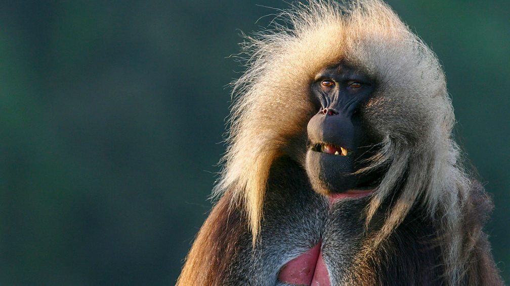
Africa’s Wild Heart – Grass: On the vast savannahs, grazers and predators struggle to outwit each other, forcing primates to develop social systems. Visible from space, Africa’s Great Rift Valley runs three thousand miles from the Red Sea to the mouth of the Zambezi. It’s a diverse terrain of erupting volcanoes, forest-clad mountains, spectacular valleys, rolling grasslands, huge lakes and mighty rivers, and is home to crocodiles, hippos, lions, elephants, flocks of flamingos and a diversity of indigenous peoples.
Using state-of-the-art high definition filming techniques, this series investigates the geological forces which shaped east Africa’s Great Rift and which make it one of the world’s most wildlife-rich landscapes. The Great Rift Valley provides the stage for an epic battle between trees and grass – its course influenced by volcanic eruptions, landscape and rainfall. On its outcome rests the fate of Africa’s great game herds. In the rift’s savannas, grazers and their predators struggle to outwit each other, forcing one group of primates to develop a social system that paved the way for the evolution of mankind.
Africa’s Wild Heart – Grass
The Great Rift Valley is a series of long, steep-sided valleys that runs through eastern Africa, from the Red Sea to Mozambique. It is a geological feature that was created by the movement of tectonic plates over millions of years. The Great Rift Valley is home to a number of unique species of plants and animals, and it is also an important source of fresh water for the region. The Great Rift Valley is approximately 6,000 miles (9,656 kilometers) long and up to 50 miles (80 kilometers) wide in some places. It is made up of a number of different valleys, including the Jordan Valley, the Dead Sea Rift, and the East African Rift.
The Great Rift Valley is a popular tourist destination, with a number of national parks and other protected areas that offer opportunities for wildlife viewing, hiking, and other outdoor activities. It is also an important cultural and historical region, with a number of ancient human settlements and archaeological sites.
The East African Rift follows the Red Sea to the end before turning inland into the Ethiopian highlands, dividing the country into two large and adjacent but separate mountainous regions. In Kenya, Uganda, and the fringes of South Sudan, the Great Rift runs along two separate branches that are joined to each other only at their southern end, in Southern Tanzania along its border with Zambia. The two branches are called the Western Rift Valley and the Eastern Rift Valley.
The Western Rift, also called the Albertine Rift, is bordered by some of the highest mountains in Africa, including the Virunga Mountains, Mitumba Mountains, and Ruwenzori Range. It contains the Rift Valley lakes, which include some of the deepest lakes in the world (up to 1,470 metres (4,820 ft) deep at Lake Tanganyika). Much of this area lies within the boundaries of national parks such as Virunga National Park in the Democratic Republic of Congo, Rwenzori National Park and Queen Elizabeth National Park in Uganda, and Volcanoes National Park in Rwanda. Lake Victoria is considered to be part of the rift valley system although it actually lies between the two branches. All of the African Great Lakes were formed as the result of the rift, and most lie in territories within the rift.
In Kenya, the valley is deepest to the north of Nairobi. As the lakes in the Eastern Rift have no outlet to the sea and tend to be shallow, they have a high mineral content as the evaporation of water leaves the salts behind. For example, Lake Magadi has high concentrations of soda (sodium carbonate) and Lake Elmenteita, Lake Bogoria, and Lake Nakuru are all strongly alkaline, while the freshwater springs supplying Lake Naivasha are essential to support its current biological variety. The southern section of the Rift Valley includes Lake Malawi, the third-deepest freshwater body in the world, which reaches 706 metres (2,316 ft) in depth and separates the Nyassa plateau of Northern Mozambique from Malawi; it ends in the Zambezi valley.